Rural Electrification
Rural electrification is critical to poverty reduction and underlies the achievement of many of the Millennium Development Goals in sub-Saharan Africa including objectives related to health, education, agriculture, environmental sustainability and gender equality. In many countries, rural electrification rates have remained in the single digits, leaving households to rely on expensive and inefficient fuel-based lighting, disposable batteries, and limited access to power for mobile phone recharging. Programs to extend national electricity grids have often lacked systematic planning to account for population distribution, the needs of social institutions such as rural schools and health centers, and the potential for off-grid or decentralized systems such as solar photovoltaics to cost-effectively serve remote and sparsely populated areas. Coordination across sectors, a national perspective, incorporation of a range of off-grid technologies, and a longer planning horizon (e.g. 10 years or more) are needed to rapidly and cost-effectively scale-up rural access to electricity.
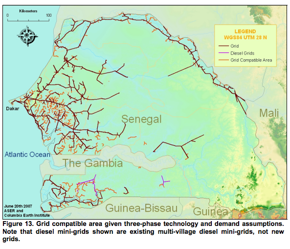
The Modi Research Group at the Earth Institute at Columbia University has developed an electricity planning and investment costing model to support national efforts to expand electricity access. This Python-based tool performs spatial processing and analysis, using simple geospatial and population data, and algorithmically generates a comprehensive and cost-optimized electricity plan, including a map of the projected grid extension grid, sites to be served by off-grid technologies, and all related costs. The model has been applied in Senegal and Kenya, and has generated interest among energy planners in ministries, utility companies, and international organizations. The project has been supported by the Bill & Melinda Gates Foundation and the World Bank’s Africa Energy Group.
The project team consists of graduate students and staff with expertise in economic development and energy policy, as well as skills in GIS analysis, and computer programming.
Related Papers/Documents: