This tool enables a fast transition from raw geospatial data to preliminary electrification network estimates. It includes:
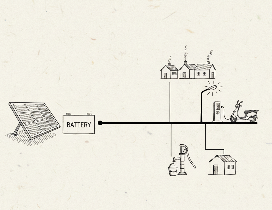
Given a mini-grid load profile, the tool sizes solar, battery, and diesel systems to meet demand, outputting levelized generation costs. It also integrates load shedding and flexible load functions.
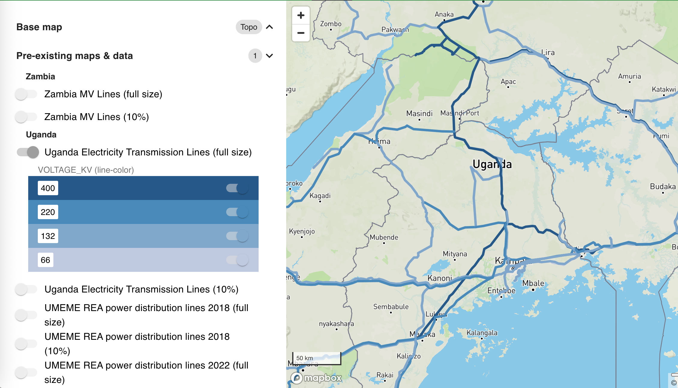
This platform visualizes data collected through the "Using Data to Catalyze Energy Investments" project to facilitate data-driven planning. Data is presented in a common map-based platform, and geographical visualizations and aggregations by geopolitical entities.
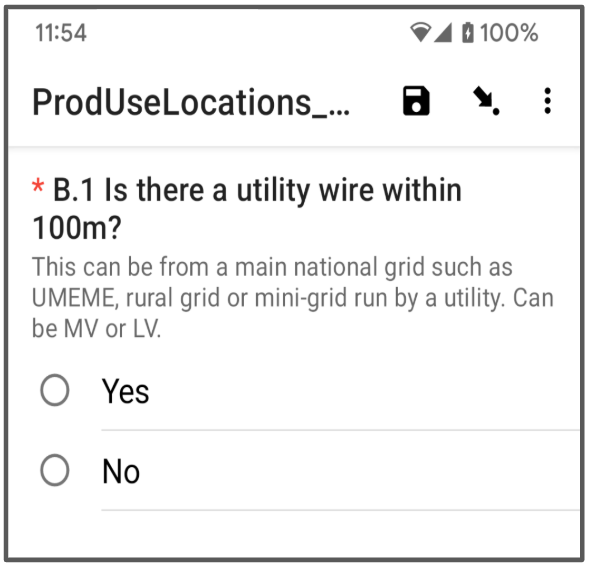
Six survey instruments were developed to capture and characterize the rural energy demands throughout Uganda: Productive Use of Energy (PUE), Market Center, Farmer Interview, Plot Observations, Light Use Shops, and Energy Issues and Priorities. Surveys were coded and conducted using KoboToolbox, and have been converted to easy to review pdf versions that can be found at the links below.

Network Planner is an online tool for planning grid, mini-grid, and off-grid electricity from the community scale to national scale. Network planner takes a host of inputs, including geo-spatial population distribution, costs of energy technologies, electricity demand and population grow-fluidth, and existing grid network, and output the least-cost solution.
Dokomo Forms is an offline-capable mobile data collection tool. Dokomo Forms allows anyone to deploy a survey effort that leverages the flexibility and capability of mobile phones while remaining fully functional offline.

Processes of evidence-based planning require base layer data about social infrastructure, as well as population, and resource maps. The Development Planning Toolkit is a packaging of the learnings of the Sustainable Engineering Lab into data collection instruments and training packages to enable any group to collect the requisite data for planning tasks such as: electrification, increasing water access, increasing access to maternal health care, improving literacy etc.

Enketo (Smart Paper) allows for offline data collection from any modern device, allowing data collection teams to seamlessly integrate mobile- and laptop-based data collection. Enketo is a joint project by Enketo LLC and the Sustainable Engineering Lab.

Formhub makes mobile data collection easy for anyone to use. Authors write surveys in Excel, use an offline-capable application Android phones to capture surveys (that can include GPS and photos), and easily visualize submitted data. Formhub can be used by anyone, and has been used widely by 2,000+ users to submit 800,000+ individual surveys.

In humanitarian disasters people affected by the unfolding tragedy need information as much as physical necessities. The Humanitarian Data Toolkit is a ruggedized, self-contained data collection toolkit that makes it possible to conduct rapid mobile and paper based data collection and analysis in an off-line and off-grid environment. The Humanitarian Data Toolkit is a joing project between the Sustainable Engineering Lab and Internews.

Millennium Villages Information System, or MVIS, is a web-based data entry and visualization tool, which is accessible in low-connectivity settings. MVIS provides a single place for multi-sector, multi-source, multi-site aggregated information on project or program performance to assist decision-makers at all organizational levels. MVIS is a joint project between the Sustainable Engineering Lab and the Millennium Villages Project Outcome Monitoring team.
NMIS visualizes data for schools, health clinics, and water pionts to facilitate data-driven planning across hundreds of Local Government Areas in Nigeria. Local planning and centralized review of local plans are facilitated by data about geo-located social infrastructure in a common map-based platform, and geographical visualizations and aggregations by geopolitical entities.

Data collection is essential to the development planning process and is a foundation of SEL’s work. Smartphones have made the collection of physical points quick and easy. However, in large, national-scale mapping efforts, it is very difficult to ensure complete coverage in a single collection effort and during multiple efforts to avoid duplication of points. Revisit, currently in development with funding from the Bill and Melinda Gates Foundation, aims to streamline the collection process as well as build a central facility repository that enables countries and organizations to share basic facility data—helping to coordinate aid and maintain a more complete and up-to-date picture of social infrastructure.

Traditional planning techniques are population-based (eg. X health clinics for Y people). Spatial Planner makes resource planning geography aware: given geographical population distribution and locations of existing infrastructure, this web-based tool recommends where to put new facilities so that the most people are closest to social infrastructure.